Wednesday, July 23, 2008

-Meghalaya

Meghalaya is one of the country’s newest states with its capital at Shillong. For long a summer retreat of the British, the beautifully kept golf course and several English country cottages testify to another influence besides the local one. Meghalaya or the 'abode of the cloud' is meant for Gods to live in with its pure atmosphere. Its sweet water and peaceful environment would attract even Gods. It invites you with open arms to spend some time in its lap of nature. Tucked away in the hills of eastern sub-Himalayas Meghalaya is one of the most beautiful states in India. Nature has blessed her with abundant rainfall, sun-shine, virgin forests, high plateaus, tumbling waterfalls, crystal clear rivers, meandering streamlets and above all with sturdy, intelligent and hospitable people. Beautiful lakes and falls, hillside cottages, a large university, and the popular Bara Bazar are quaint aspects of this town.

Shillong

The place, the people and the climate all combine to create an atmosphere to make Shillong an ideal holiday resort throughout the year. Cherrapunjee, the wettest place on earth is only 56 kms away from Shillong. Shad Sukmynsiem means dance with joyful heart. It is a thanks giving dance, held in shillong in the month of April every year.

Altitude: 1496 meters. Climate (deg C): Summer - Max 23.3, Min 15. Winter - Max 15.6, Min 3.9. Season: Throughout the year.

Places Of Interest:

Ward Lake, Botanical Garden & Museum, Meghalaya State Museum, Lady Hydari Park & Mini Zoo, Crinoline Falls & Swimming Pool, Wei Tdem (Sweet Falls), Shillong Peak, Elephanta Falls, Arunachal Pradesh Museum, Iewduh Bara Bazar, Butterfly Museum, Bishop & Beadon Falls, Shillong Golf Course, Polo Grounds, Umian Lake.


Excursions:
Cherrapunjee- 56 kms, Dwaki- 86 kms.


Reach -
By Air: Nearest airport Guwahati- 129 kms and Umroi Airport- 31 kms are connected with Calcutta.
By Rail: Nearest Railhead is Guwahati- 103 kms.
By Road: Calcutta- 1184 kms, Darjeeling- 690 kms, Gangtok- 692 kms, Guwahati- 103 kms, Kaziranga- 294 kms, Aizwal- 430 kms, Siliguri- 578 kms, Manas- 273 kms, Agartala- 499 kms, Kohima- 469 kms, Itanagar- 481 kms.

-Mizoram

The youngest state Mizoram, formerly known as the Lushai Hills is situated in the North Eastern Corner of India. It is flanked by Bangladesh and Tripura in the West and Burma in the East. Scenic beauty combined with mild climate adds to the charm of a generous people. The beauty of Mizo society is that westernization mixes harmoniously with local traditions. Music and dance is the sprit of their culture. Mizoram is also a botanist's paradise as there are many kinds of orchids, wildflowers and herbs found over here.


Altitude: 3715 feet. Temperature (Deg C): Summer - Max. 29, Min. 20. Winter - Max. 21, Min. 10. Rainfall: Approx. 200 cms to 350 cms. ( May to September ). Best Season: September to May.


Places Of Interest:
Aizwal Town, Mizoram State Museum, The Weaving Centre, Bora Bazar, Luangmual Handicrafts Centre, Zoo.


Excursions:
Tamdil- 60 kms, Champai- 192 kms, Lunglei- 235 kms, Tawi- 140 kms, Saiha - 360 kms, Phawngpuri, Dampa, Kolasib.

Reach -
By Air: Aizwal is connected with Guwahati, Silchar & Calcutta which in turn is connected to major cities.
By Rail: Nearest railway station is Silchar (Assam)- 180 kms from Aizwal and Guwahati- 397 kms from Silchar is connected with the most of the major places in India.
By Road: Guwahati- 506 kms, Imphal- 374 kms, Kohima- 497 kms, Shillong- 430 kms, Agartala- 443 kms.

-Nagaland

Kohima--Dimapur

Nagaland is a world apart. Nature resplendent in all her full-bodied glory. Exquisitely picturesque, vibrantly colourful, all lush fertile, the land represents unimaginable beauty, created by nature, to take your breath away... The Nagas, inhabitants of Nagaland, are said to belong to the indo-mongoloid stock, a race whose presence was first noted ten centuries before Christ, at the time of the compilation of the Vedas. Nagaland is bounded by Assam in the west, Burma on the East, Arunachal Pradesh & Assam on the North and Manipur in the South. The state consists of seven districts with sixteen tribes & sub-tribes inhabiting it. The Naga tribes are generally full of folklore. They are fond of seasonal songs, solo, duet and choric. Here man has to fight nature all the time. The struggle however, makes people tough. The people here are strongly built, simple, honest and hard working.


Altitude: 1495 meters above sea-level. Main Rivers: Dhansiri, Doyang, Dikhu, Milak, Zungki and Tizu. Highest Peak: Saramati (3877 meters above sea-level). Area: 16,527 Sq. Kms. Tribes: Angami, Aao, Sema, Lotha, Rengma, Chakhesang, Sangtam, Konyak, Phom, Chang, Yimchunger, Khiamungan, Zeliang, Kuki and Pochury. Climate (deg. C.): Summer- Max.31, Min.16. Winter- Max.24, Min.4. Average Rainfall: 250 cms (100). Clothing: Summer- Cotton Tropical, Winter- Heavy Woolens. Languages Spoken: Nagamese, Local dialects, Hindi, English etc. Best Season: October to May.


Kohima


Kohima, State Capital & hill station is situated at an altitude of 1495 meters above sea-level. It is a beautiful town presenting wide panoramic views. Mokokchung is the centre of the culture & traditions of the Ao Nagas.

Places Of Interest:
War Cemetery, The State Museum Sales Emporium, Cultural Center, Zoological Park, Cathedral, Kohima Village (Bara Basti).

Excursions:
Khonoma village-20 kms, Mokokchung- 160 kms.

Reach -

By Air: Nearest airport Dimapur- 74 kms.
By Rail: Dimapur- 74 kms, the nearest railhead, is directly connected to Guwahati which in turn is directly connected to all the major places. Guwahati - Dimapur.
By Road: Dimapur- 74 kms, Imphal- 145 kms, Guwahati- 390 kms, Shillong- 490 kms, Calcutta- 1,516 kms.


Dimapur


Situated at an altitude of 195 meters above sea-level is the gateway of Nagaland. This flourishing town is also the commercial centre of the State. Dimapur is the main rail-head in Nagaland. Dimapur is the only airport in Nagaland. Indian Airlines operates Boeing services from both Calcutta and Delhi on every alternate day.

Places Of Interest:
The Ruins of Medieval Kachari Kingdom, Ruzaphema- 5 kms, Intangki Wildlife Sanctuary- 37 kms, Sales Emporium.

Tuesday, July 22, 2008

-Orissa

[Enchanting Odissi-Rare Artistry-Gourmet Delights-The Ethnic World of Orissa] Bhubaneshwar- Udaygiri Khandagiri- Dhauli- Puri- Konark- Chilka Lake- Gopalpur- Simplipal- Chandipur

Orissa has a chequered history which has successfully assimilated and synthesized the best of Buddhist, Jain and Hindu cultures. Orissa or Kalinga as it was then called was a settlement of non-Aryan and Aryan settlers. It was here that the famous Battle of Kalinga was fought which made King Ashoka forsake war. He became a follower of Buddhism and spread the spirit of ahimsa and peace. It is to the Kharavela period that Orissa owes its Jain art and architectural tradition. The sophisticated architectural style of the Jain Monastic caves at Udaygiri and Khandagiri are a story unto themselves. To understand all that a Hindu temple stands for one must realize that temples in India are not merely abodes of deities but a shradhanjali (offering) to the most sacred. Here a ’darshan’ is a communion between man and his creator. Hence, Orissan temples are characterized by profuse decorations, exquisite carving and ornamentation covering the entire visible area with Gods & Goddesses, kings and queens, animals and flower motifs ranged against each other. They radiate the artist’s inner love and dedication. Orissa is probably the only state where one can study temple architecture in all its successive stages of development.

Enchanting Odissi

Odissi, is the traditional dance form of Orissa and probably owes its origin to the temple dances of the devadasis (temple dancers). Possibly the oldest classical dance form, one must sit through a performance to experience its sheer lyrical grace. Mentioned in inscriptions, it is depicted on sculptures, in temples like the Brahmeswara and the dancing hall of the Sun temple at Konark. In fact in the 1950’s the entire Odissi dance form was revitalized with the help of the Abhinaya Chandrika and sculpted dance poses found in temples. Orissa enjoys a rich tradition of tribal and folk dances as well. Chhau from Mayurbhanj District is a martial dance form reminiscent of Orissa’s earlier maritime tradition. Other folk and tribal dances include Danda Nata, a daylong performance ending in acrobatic sequences, Ranapa or dances in which dancers perform balancing acts on bamboo stilts.


Rare Artistry
Land of dexterous artists and craftsmen, Orissa possesses a rich artistic tradition which enjoyed liberal patronage from the temples as well as the nobility. Diverse and varied, the craftsmen artists of Orissa still retain their indigenousness, trying to refine it to suit a changing sensibility. Be it the appliqué artists of Pipli or the stone carvers of Orissa, proud descendants of sculptors whose hands chiseled the unsurpassable designs on Orissa’s famous temples, the essential conflict between the traditional and the modern is gradually being resolved. The progressive attitudes of the Orissan artists coupled with hereditary skills zealously perpetuated, has given traditional Orissan arts and crafts like weaving of Ikat, Bomkai and Sambalpuri Saris, stone carving, appliqué and embroidery, silver filigree work, patta painting and palm leaf engraving, brass and bell metal work, lacquered boxes and toys and basket weaving, a unique place in the connoisseur’s dictionary the world over. A visit to the Raghurajpur artists village and Pipli, near Puri, to see the artists at work is quite a rewarding experience.

Gourmet Delights

The green coconut with its pure water and the abundant sea food from Chilika lake and the sea are as Orissan as pizzas are Italian. Delicious prawns, crabs, sweet water fish, lamb, chicken and eggs cooked by Orissan cooks are widely available gourmet fares, while specialty restaurants serve almost everything. Milk preparations like Rasgulla, Rasmalai, Khirmohan, Rasabali, Kalakand are delicious. Pithas, sweet and savoury are served as local snacks. This is a traditional preparation requiring skill and care. Pithas like Mandas, Kakara, Chhunchipatra are usually domestic preparations much loved by the Orissans.


The Ethnic World of Orissa


Orissa is a modern state with an ethnic past that is still vibrant. Most of her tribes are to be found in the districts of Mayurbhanj, Keonjhar Phulbani, Sambalpur, Kalahandi and Koraput. As many as 62 tribes exist in Orissa - Kondhs, Koyas, Bondas, Gadabas, Santals, Juangs, Oraon, to name only a few are some important tribes who have retained their individuality and their close bond with nature. From the last week of January to early February, the Tribal Fair at Bhubaneshwar brings together the ethnic world; their art, craft and culture is on display. For those desirous of a closer look trips are arranged by many tour operators from Bhubaneshwar and other cities but it is a hardier trail and more time consuming.


Bhubaneshwar


Bhubaneshwar is the temple city of the east. The ancient city of Bhubaneshwar (Bhuban being world and Iswar God) is a walk down centuries of temple architecture. It is probably the only city in the world that enables an authentic over-view of the stages of development of Hindu religious architecture. In the fast moving world of today these temples are a gentle reminder of the splendor, the heritage that was once India. Regular dances by the ’Devadasis’ or divine servant girls, rituals and rites, recital of hymns were all an integral part of temple culture. Temples in Bhubaneshwar are built on a common plan as prescribed by Hindu norms. All visible parts of a temple are sculpted with motifs of priests, kings, courtiers, pilgrims, celestial dancers, couples in embrace, birds, animals or scenes from religious epics and legends.


Area: 65.03 sq km. Altitude: 45 meters (146 ft.) Temperature (deg C): Summer - Max.38, Min.27.1. Winter - Max.28.2, Min.15.2. Rainfall: Mid June-September 60 inches (152 cms). Languages Spoken: Oriya, Bengali, Hindi, English. Best season: October to March.


Excursions:
Dhauligiri- 8 kms, Udaygiri Khandagiri- 8 kms, Nandan Kanan Zoo- 25 kms, Chandipur- 16 kms, Pipli- 29 kms, Atri Springs- 42 kms, Sun Temple, Konark- 65 kms.

Reach -
By Air: Connected with Bombay, Calcutta, Delhi, Hyderabad, Nagpur, Varanasi, Raipur and Vishakhapatnam.
By Rail: Directly connected with Calcutta, Puri, Madras, Delhi, Bombay, Bangalore, Guwahati, Hyderabad, Tirupati, Trivandrum.
By Road: Calcutta- 480 kms, Chilka Lake (Barkul)- 130 kms, Cuttack- 32 kms, Gopalpur- 184 kms, Konark- 64 kms, Madras- 1225 kms, Puri- 62 kms.


Udaygiri Khandagiri

7 kms from Bhubaneshwar are the twin hills of Udaygiri and Khandagiri. Built by Kharavela around 1st - 2nd Century BC for Jain monks, they are excellent examples of Jain Cave art. The famous caves of Hathigumpha (elephant cave) in Udaygiri, RaniGumpha (Queen’s cave) also in Udaygiri, with upper and lower stories, spacious courtyards and extremely delicately designed friezes bear witness to the sophistication the architectural styles had attained as early as the first Century BC.


Dhauli

Driving down the Puri-Konark Highway from Bhubaneshwar one comes across Dhauli hill on the banks of the River Daya. Surrounded by the soothing greenery of paddy fields, lies the 3rd Century BC Ashokan Rock Edict, a memory of the gruesome war that transformed Ashoka, the great Warrior into a Buddhist missionary. The Peace Pagoda built in collaboration with the Kalinga – Japanese Buddhist Sangha, on the opposite hill, is completely modern and is an excellent foil.


Puri


The seat of Lord Jagannath, Site of Renowned Rathyatra Festival and one of the most popular sea side resorts on the Bay of Bengal, Puri is an ideal travel destination all the year round.


Places Of Interest:
Shri Jagannath Temple, Daria Hanuman and Sonar Gouranga Temple, Gundicha Char, Indradyumma Tank, Narendra/Chandan Tank, Loknath Temple, Swarga Dwar, Sea Beach at Puri.


Excursions:
Sakshigopal- 19 kms, Konark- 31 kms, Bhubaneshwar- 63 kms.


Reach -
By Air: The Nearest Airport is Bhubaneswar- 65 kms.
By Rail: Well connected to Berhampore (Orissa), Bhubaneswar, Calcutta, Cochin, Delhi, Guwahati, Hyderabad, Madras, Tirupati, Trivandrum, Varanasi.
By Road: Bhubaneshwar- 62 kms, Calcutta- 541 kms, Chilika- 167 kms, Konark- 31 kms, Madras- 1285 kms, Sambalpur- 362 kms, Vishakhapatnam- 486 kms.


Konark

Renowned for its magnificent sun temple, Konark is also a lovely beach resort. In Konark, the
"Natya Mandir", the dance hall of the Sun Temple probably remains as the last remnant of the glorious temples of Orissa an extant example of the architectural excellence of the times. Built in the 13th Century, here a colossal image of the chariot of the Sun, drawn by seven horses and 24 wheels symbolizes the divisions of time. The Konark Sun Temple also houses a Natamandira or dancing hall. Only two subsidiary temples out of the 22 exist today. The Vaishnadevi Mayadevi Temple stand to the West it. The Sun temple of Narasimhadeva is a depiction in stone of the life of those times – royal, social, religious and military. The intricate carvings on the walls and wheels of the chariot are unprecedented in history.

The fine sculptures depicting Court life, hunting, scenes, celestial deities are epitomes of precision and grace. Graceful sculptures from the world of the Kamasutra, epic of eroticism also adorn the structures. The Sun Temple standing in solitary splendor is the relic of a great past. y.


Area: 2.5 sq km. Altitude: Sea level. Temperature (deg C): Summer- Max. 43, Min. 32.2. Winter- 26.7, Min. 10.6. Rainfall: 152.4 cms (July to September). Clothing: Summer- Light tropical & cottons, Winter- light woolens. Languages spoken: Oriya, Bengali, Hindi, English. Best season: Throughout the year, but preferably October to March.


Reach -
By Air: Nearest airport Bhubaneshwar- 64 kms is connected with Calcutta, Delhi, Hyderabad, Madras and Nagpur.
By Rail: Nearest railheads Puri- 31 kms and Bhubaneshwar- 64 kms are connected with the major places.
By Road: Konark is well-connected with Bhubaneshwar as well as the major places.


Chilka Lake


Chilika Lake, spreading over an area of 1100 sq. kms is the largest brackish water lake in the country and attracts large number of migratory birds besides resident ones. Barkul and Rambha are two places on the lake which serve as the base. Though the lake can be visited throughout the year, October to March is the best season.

Flora:
The lake harbours the "aquatic vegetation" of its own and is typically represents by Algal forms, a number of Diatoms/Phytoplanktons and a few species of brackish water submerged phanerogams like Potamogeton pectinatus, Halophila ovalis etc. The present scanty littoral and scrub jungles on lake margin, islands and rocky faces are represented by the species like Salvadora presica and a number of climbers and herbaceous ground flora.

The dunes & sandy areas of the beaches near lake have the floral composition of their own, favoured in the conditions they offer. The land lying between Sea and Lagoon exhibits rich growth of casuarinas equisetifolia.

Fauna:


There is a wide variety of animal life forms representing various groups of Animal Kingdom ranging from Protozoa to Mammals. Around 158 species of fishes and prawns have so far been recorded.

Some mammals reported from small pockets in the surrounding hills/forests/scattered islands & amidst the vegetation of sandy ridge facing Chilika and Sea include Black bucks (Antelope cervicara), Spotted deer, Fox, Jackal, Hyena, Jungle Cat, Hare, Rat, Pachyura (an insectivora) etc.


Area: 1100 sq. kms. ( Wildlife Sanctuary area- 15.53 sq. kms.) Temperature (deg C): Summer- Max. 37, Min. 30. Winter- Max. 24, Min. 17. Rainfall: 1160 mms. (Mainly July to September). Clothing: Tropical. Languages Spoken: Oriya, Bengali, Hindi, English. Best Season: Throughout the year.


Places of Interest:
The lake with several of its islands, main among them being, kalijai, Nalabana, Honeymoon, Breakfast islands etc. Satpada towards the South Eastern stretch of the lake is closer to puri and is fast developing as a tourist spot on the shore of Chilika.


Cruise on the lake:
To visit various islands, particularly, Kalijai & Nalabana as well as to cruise on the Chilika Lake, motorised Yatch and speed boat services are available at fixed rates from the Manager, O.T.D.C., Panthniwas, Barkul.


Excursions:
Narayani- 22 kms from Rambha, Gopalpur-on-Sea- 45 kms from Rambha and 75 kms from Barkul, Taptapani Sulphur Spring- 100 kms from Rambha and 130 kms from Barkul.


Reach -
By Air: Nearest airport Bhubaneshwar is 105 kms from Barkul & 135 kms from Rambha.
By Rail: The nearest railheads are at Balugaon- 7 kms from Barkul and Rambha which are directly connected to Calcutta, Puri, Madras, Hyderabad and Bombay.
By Road: Barkul to Bhubaneshwar- 105 kms, Puri- 167 kms, Cuttack- 133 kms, Berhampur- 78 kms, Gopalpur-on-Sea- 75 kms and Rambha- 30 kms.


Gopalpur


Gopalpur-on-Sea is a quiet and charming sea resort along the Bay of Bengal, in the district of Ganjam, Orissa. It 
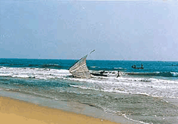
offers secluded environment and magnificent sun, surf and sand for most of the year.


Altitude: Sea level. Temperature (deg C): Summer- Max. 35, Min. 23. Winter- Max. 27, Min. 16. Rainfall:Languages Spoken: Oriya, Hindi, English. Best Season: Throughout the year, preferably October to April. 118.7 cms (46.7 inches).


Places Of Interest:
Gopalpur is situated right on the Bay of Bengal with a beautiful sea-beach.


Excursions:
Chilika Lake- 45 kms from Ramba and 75 kms from Barkul, Nirmaljhar- 56 kms, Taptapani (sulphur spring)- 67 kms.


Reach -
By Air: Bhubaneshwar is the nearest airport- 180 kms.
By Rail: Berhampur- 16 kms is the nearest railhead.
By Road: Barkul- 75 kms, Berhampur- 16 kms, Bhubaneshwar- 180 kms, Puri- 242 kms.


Simplipal


Nestled in the centre of Mayurbhanj, the northernmost district of Orissa is the Similipal National Park one of India's better known wild life sanctuaries, covering a large forested area of 2750 sq.kms. The variation in topography, climate and vegetation has supported large varieties of animals, birds and reptiles. Similipal is one of the earliest and finest of India's fifteen Tiger reserves under Project Tiger.


Area: 2750 sq km. Altitude: 559.31 meters above sea level. Temperature (Deg C): Summer- Max.40, Min.20. Winter- Max.20, Min.4.4. Rainfall: 1648 mm ( Mid. June to Mid. September ). Best Season: 1st November to 15th June. December to February is extremely cold. (The reserve remains open from 15th Oct. to 15th June).


Places of Interest - Fauna found at the Park include the tiger, leopard, elephants, bison, sambar, porcupine, pangolin, flying-squirrel, hill myna, hornbill, python etc.


Excursions - Kiching- 50 kms from Joshipur.

Reach -
By Air: Nearest airports are Calcutta- 250 kms and Bhubaneshwar- 300 kms.
By Rail: Balasore- 76 kms from Lulung. Jamshedpur- 115 kms from Jashipur.
By Road: Baripada- 20 kms, Jashipur- 114 kms, Bhubaneshwar- 320 kms, Calcutta- 250 kms from Lulung.


Chandipur


Chandipur- 16 kms away from Balasore Railway Station on Howrah-Madras line of South Eastern ( S.E.) Railways annique beach where the sea water recedes about 5 kms during low-tide and advances to the shore line again during high-tides each day. An ideal beach resort of Orissa.


Reach -
By Air: The nearest Airport is Bhubaneshwar- 230 kms from Chandipur.
By Rail: The nearest railhead Balasore- 16 kms.
By Road: Balasore- 16 kms, Bhubaneshwar- 230 kms, Cuttack- 230 kms, Calcutta- 240 kms.